02.27.12 Core Team Meeting
Present: Kinny Perot, Robin Morris, Kate Stephenson, Kathy Meyer, Abby Martin, Peter Lazorchak, Tony Stout, Andres Torizzo
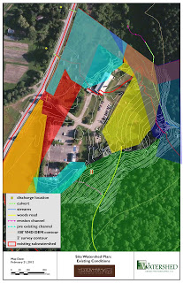
First we reviewed Andres and Tony's work to date, including the watershed maps they created delineating three different sub-watersheds on the property and where they drain under Rte 100. It shows the current long culvert (dotted green line) and their best guess as to where a more natural water path would go (blue arrow on the map). We also discussed that the existing culvert continues from our property onto our neighbor's property (to the north) and that we should probably initiate a conversation with them regarding our plans for changing the water flow.
Overall Watershed Context (aerial photo w/ contours)
Site Watershed (zoom)
Tony also showed us another iteration where he had shaded in the  various setbacks to the site: 200' from centerline of Rte 100, 75' from each property boundary, 50' wetland buffer, stream setbacks (100' on the steep slope sections and 50' on the flatter sections where the existing culvert runs) and identified ag soils and existing ag land. He also noted that all the forested area is considered a deer yard according to Fish and Wildlife mapping and it's possible that they could require a buffer as well.
Site Watershed with setbacks
We discussed the need to have additional wetland mapping done for the wet area to the south of the Chalet and tennis courts. By determining whether this is Class II or Class III wetland, it will inform us as to the necessary buffers (50' for II, 25' for III). Also if the disturbance to the wetland is under 3000 s.f. then we would not need a permit from the Army Corps of Engineers. Peter has a new colleague in his office who is a wetland mapping specialist however given the recent snow he was not sure she would be able to make the determination immediately. Most definitely either way the wetland location will impact the proposed entrance driveway location.
Then we reviewed two drawings from Peter Lazorchak's team. One shows the whole site and identifies all steep slopes with grade higher than 25% (these are the shaded parts). The other zooms in to the developed area and has all of the buildings and infrastructure from the Regenesis plan added in to the existing topography from our latest surveys. Peter's plan also incorporated some of the setback lines, including an assumed 50' wetland buffer and stream setbacks at 100' (upper stream) and 50' (lower section currently in culvert). He also brought up the issue of wastewater setbacks. While he is very supportive of alternative wastewater treatment and using constructed wetlands he feels strongly that the state will still require us to have in ground dispersal (leach fields). The leach field needs to be at least 30' downhill from any buildings and 75' uphill from any buildings. This means that the "upper meadow" area available for leach field would be significantly limited. We discussed potential other areas on the plan that might be considered for leach field beyond the previously permitted meadow.
02.21.12 Site plan w/ proposed buildings (whole site)
02.21.12 Site plan w/ proposed buildings (zoom)
We discussed how before Andres and Tony move forward with their 3 concept designs for stormwater, the Core Team needs to do a review of the proposed building locations to "massage" it in response to what we now know about setbacks.
Next steps:
- Andres and Tony to look more closely at our existing Act 250 permit for references to habitat and ag soils
- Peter to follow up with his colleague Kristin re: scheduling wetlands mapping
- Core Team to meet Thursday March 1 at 8am (at Kinny's) to review findings and next steps
- Core Team will follow up with Andres and Tony when we have a better sense of what buildings would move before they move forward with three concept designs.
